(July 26th – 30th, 2026)
The suede brown purebred steed hardly budged as I lunged my weight forward in an attempt to swing my backpack further over the center of horse after initially pulling myself up as much as possible from the stirrups. As I found my balance, the horse settled and awaited my further action. I somehow had expected it to already know what to do, but now realized I was in fact driving this horse, not the villager who was loaning it to me. Neither were they crossing the raging torrent of glacial runoff that I found myself staring past to the dry, polished rocks far on the other side of the shore. The width of the river appeared to have grown despite now being higher up on a horse.
With the awkwardness of the backpack on my shoulders, it’s a poor time to also realize this may be my first time on a horse in nearly a decade, not since my occasional horseback commutes as a Peace Corps volunteer when for a time I had fiercely contemplated the purchase of one for my regular transport in rural Ecuador. As perhaps one of my few regrets in life, I recognize my skills may be sharper and more confidence instilling had I gone through with that decision then. Now I was faced with recalling what I knew from that distant past.
With a deep breath I lightly kick in to the side of horse in an attempt to signal movement but not instigate reprisal. The horse promptly proceeds into the rushing current. The firsts steps are rather confident and firm. Despite a mild rocking back and forth on those entry steps, I recognize I am committed now and that this may be a ton of fun.
With the third and fourth steps, the horse violently sinks above its knees into the gurgling churn of the waters, and I raise my boots out in front of me to avoid soaking them. In a sudden reversal of sentiment, I begin to question whether simply fording the river on my own a bit further down at the braid was the far more reasonable choice. A fall from a horse with a backpack on would be doubly worse than a botched retreat from crossing on foot.
Recognizing it’s all or nothing, I kick again and hee-haw in my best cowboy accent to maintain the forward momentum. I take note of a slightly shallower looking course and pull the reigns of the horse to the left to navigate into that channel. We begin to rise again and gain footing near the other side. After we successfully climb to dry ground I dismount in a sense of revered glory and demonstrative valor.
It may not have been wholly necessary, but having never ridden a horse across a glacial outflow before, it was a thrilling way to begin the day.

Now it was Kate’s turn. She also rises to the occasion, as most hikers of the famous Mestia- Ushguli trekking route do outside the village of Adishi to cross the Adishchala river en route to climb the pass of Chkhunderi, 500 meters above. In early season, it is hardly a choice with the high water of spring snow melt, but in late July it was more of a novelty to pay the modest fee to the villagers for use of a horse to cross.
It was our fourth day of hiking in the Upper Svaneti region of Georgia, and despite proving a rather popular track, the combination of jaw dropping glaciers, flowery hillsides, and exquisite cuisine paired with medieval villages was unmatched in its variety in my experience to-date.
—
We started our five-day journey further west of the regional capital and traditional starting point of Mestia, opting instead for the small village of Esteri, which would allow for a couple days of hiking prior to encountering the steadier crowds of the main route. It also allowed for a rising crescendo of mountain viewpoints and glacial observations as we advanced eastward towards Ushguli, the landmark UNESCO world heritage site and most iconic of the Svan ethnic villages.
Upon cresting Bak pass on our first day, the prominent lower façade of the great Ushba mountain, known as Mazeri, greeted us in stellar glory. While we had witnessed its snow-capped dome in the earlier morning taxi ride, Ushba was now hidden behind impermeable layers of cloud that would not release its grip for hours. As we finished our lunch, a sole hunter casually strolled passed us on his way up the mountain, an archaic looking wooden stock rifle slung over his shoulder. He asks if we have seen anything, we have not.

Based on the map, I suggest we head further north into the valley below towards a campsite on a knoll before two large waterfalls. The topography alone suggests that it would place us in an epic cradle of mountainous pinnacles. We progress in that direction on a remote track when it is suddenly intercepted by another from the other side of the river. We proceed further until soon passing a rustic restaurant and campsite with fish ponds, as well as an extensive dirt parking lot. As a dark portent, from there we soon find ourselves jostling with day hikers as we walk higher up towards the waterfalls.
“Where did all these people come from?”. Oh, how a road can kill the peace of a place.
After an hour, the camping spot proved to be an unattractive mid-trail café of-sorts, and the level of day hikers was nearly repulsive. The observation of the waterfalls lost part of their luster amongst the crowds, and we debated heading back down the valley to some quieter spots we had seen before. Despite some difference of opinions, we hiked back to the Hiker’s Inn restaurant and stopped for a beer. The beer led to a fresh fish filet straight from the ponds, and then consequently a decision to pay to camp there and make use of the sauna facility.
Anyone who knows even the slightest about me, knows that I absolutely love saunas. Proper sa-u-nas that is. And there is a severe distinction between a shitty sauna and a proper one: predominantly in the quality and combination of thoroughly sufficient heat, a fiery stove, a sizzling stone rack, and a rustic aesthetic.
Coupled with an ice cold fish pond, I thoroughly delighted in the quality of this Georgian sauna. It was an acceptable amenity to welcome as a convenience of at the end of a first day of backpacking, and perhaps among the best in my life.

—
Our second day took us past the village of Mazeri and up an impossibly steep and interminable mountain side en route to Guli pass. The hike started in a drizzling rain and later transitioned to climbing through layers of fog that playfully revealed inner folds and protrusions of cliffs from the figure of the mountain it cloaked. Occasionally, Ushba would present its dark accents of cliff bands framing portions of unveiled snowy couloirs. When the clouds lifted more significantly, it also proved disheartening to realize how little physical distance we had covered in the vertical climb to the pass.
“Well, everything does look a lot smaller now at least!”
At the pass, we snack with two Scandinavian women and revel in the occasional glimpses of expansive views to the east that unfurl from time to time with patience. The chill eventually overcomes us and we begin plodding our way a long a verdant green mountain spine that straddles two precipices of fog. Eventually, a trail cuts down and across the great valley of the Pushkueri river below.
It is delightful walking until we approach a seemingly innocuous waterfall and snowfield. The trail proceeds directly through the waterfall, which provides better than anticipated grip despite its generally steep exposure and steady flow rate. As we step down towards the snowfield, the slope sharpens and the natural bridge onto the snow bank has eroded away to within a couple feet of the edge, leaving in between and down below an icy cavern extending underneath the glacial sheet.
Carefully feeling for the best traction to the final pedestal and then lunging forward in a hopeful sense for receptive grip on top of the snow slope I manage to gain a hold.
Kate struggles with this part, rightly so. It was not fun, nor expected, after a casual hour strolling through flowery hillside displays. Eventually, after kicking out some steps and sharing words of encouragement, she also manages the transition and we continue 50 meters to the next obstacle: cutting low and wide around the eroding bridge of the snow field, or cross through the cascading creek above it.
We opt for the cascade and minimize getting thoroughly soaked, although a few quick maneuvers of rock hopping were requisite.

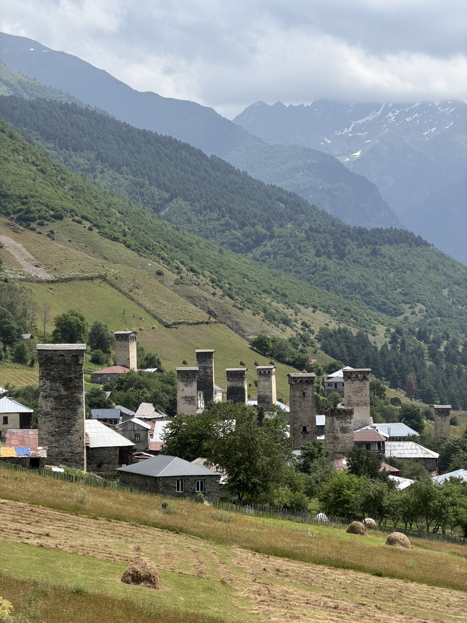
Soon after, we would pop out above Mestia on a popular day hiking trail and descend steeply into the medieval village. We opted for a guesthouse this night, ensuring to pick one that had one of the famous “lookout” towers that the Svan valley is famous for. One may clearly identify them for their obvious defensive posture, as well as grain storage capacity, but one thing that did not click for me right away was mention of their use in defense against avalanches. I lightly pondered the concept on its mention but mentally moved on soon afterwards. Days later, it clicked. Every house in a Svan village has one of these towers, and given their prominent height of roughly five stories above the main house level, in the event of an avalanche covering an entire village or home, the inhabitants would be able to climb up and out through their watchtowers to safety above the snow line. Furthermore, their positioning also encouraged deflection of the avalanche away from the main house to which it was attached to. Ingenious. Never had I seen or heard of this concept before.
Prior to hiking onwards the following day, I indulged in a cultural feature playing at a small theater in town. Advertised as the only full-length feature film in the Svan language, Dede, was a tremendously insightful cinematic drama documenting a heart wrenching love story and feminist rebellion for free will within the established cultural dogma of Svan society and familial expectations. It added just the right amount of additional context to the rooted culture and village history engrained within the mountains that I was walking.

—
The hike out of Mestia the next morning was madness. The plague of Instagram-able holidays, this most famous hike in the Georgia Caucasus featured a steady caravan of hikers ranging the full spectrum of lightweight day-packers to fully geared backpackers like ourselves jockeying for position up the steep trail to the next valley.
Fortunately, upon reaching a golden meadow clearing where the track diverged, a plethora of alternate routes presented itself and we opted for a slightly higher pathway that also brought us to a spectacular lookout on the glacial valley up beyond Mestia. Similar to my experience on the Laugavegur trail in Iceland, there are reasons why these trails have become famous, and with the right expectations they can still make for highly enjoyable and glorious walks. In fact, while we carried much of our food and tents to take advantage of flexibility in where to camp at night, I think this hike overall tilts heavily towards an ultra-hedonistic, light-weight approach, cruising from village to village eating rich and delicious Georgia food and sipping fantastic red wine along the wway.
When we reached the village of Lakhiri, I could not help but insist that we stop for some legit local Kubdari, perhaps the most savory and delicious Georgian plate I had sampled in the whole country. A form of stuffed meat pie, it is uniquely savory for its generous flavoring with Svan salt, a compelling mixture of salt, garlic, fenugreek, dill, coriander, marigold, red pepper, and cumin flavorings.

After hiking through several more small villages and taking refreshment in a small pond along a hot stretch bordering the glacial river drainage, we began a final climb for the day up the side of Tetnuldi mountain. Half way up we passed what would have been a purely epic campsite if not for its lack of water. For those camping, I highly suggest planning for this. The view warranted substantial pause and reflection. Far below, an unsuspecting village sat quietly at the cross roads of two enormous geological cavities winding their way down from their icy columns thousands of feet above and wound back several kilometers behind imperial earthen walls. It’s the kind of place that forces a recalibration for a sense of scale and settles doubts within of whether a Creator has breathed this landscape into existence after all.
As difficult as it was, we eventually moved onwards and set up a delightful camp on the backside of Tetnuldi, catching evening glows of the 16,000 ft peak along the way to camp.

—
The following morning, having crossed the Adishi outflow on horses, we climbed to Chukhunderi pass nearly 1,500ft above the valley floor. Punishingly steep, we were awarded regularly with clear views to the ice wall at the back of the valley, but for every deafening roar from glacier itself, we never could locate the precise location of the fracture or witness the icefall itself. By the time we reached the pass, however, afternoon clouds were moving in and our views afar began closing in. Again the pass resembled a floating isthmus in the sky as its slopes disappeared into fog below.

Worse, the view across the valley to Lagam pass, an alternate route we had been favoring, was fully obscured at altitude. We had contemplated enduring a big day to hike over two passes in one go, but I generally like to get eyes on high terrain before I commit. This would not be possible.
Down in the valley, Kate and I discuss our options and agree it may not be the best conditions to attempt that alternate route. We began a casual stroll down valley and came to the delightful hamlet of Khalde. Upon closer inspection, one finds that much of Khalde is not only abandoned but outright left in ruins. An interpretive display discerns the proud but fateful history of a Svan village that successfully fought Russian imperialism in 1875 only to be thoroughly punished in subsequent military actions the following year in 1876. Having enjoyed hundreds of years of autonomy within the Georgian kingdom, it was antithetical to submit to Russian taxation and religious doctrine. The result was the death, deportation, and destruction of the entire village. Years later, only a small handful of heirs from families of that village would begin returning in an attempt to cultivate life there once again. More than a hundred years later, peace has found the village, although it is not a year-long residence for anyone.
Needless to say, it was mildly comical to follow the signs down to our guesthouse through tight, overgrown pathways between 19th century stone ruins. The stone cottage we found and the hammocks set up with a peaceful valley view cast away any stubborn dwelling on the village’s troubled past. The caretaker’s son welcomed me into an entertaining round of cards with his friends as they celebrated his birthday that night.

—
The next morning, a brilliant sunshine poured into the village. Having debated with Kate the location of the village church ruins which claimed to include a piece of wood from the original cross on which Jesus was crucified, the innkeeper assured me of the correct location. Insisting we visit it properly before disembarking down valley for the final day’s hike up the traditional route to Ushguli, we turned up the trail to the original entrance to Khalde. As we crested the village hill, the view up the valley to the north was simply mind blowing.
“Woah, where did that glacier come from!?”

The curtain of clouds that socked in up-valley views yesterday had fully lifted. Additionally, a Scottish guy we had spoken with briefly the day before upon arrival to the village mentioned he was headed up to Lagam pass and would leave imminently.
“Well, hell, the weather looks significantly better than yesterday. We are in.”
In an example of how patience and a leisurely pace can net a fantastic upside, it is our reluctance to hike all that much farther the day before that left the option to route back to Lagam pass within a reasonable distance. And the weather was absolutely splendid for it.
What a gift.
Forcing outcomes often fails in the face of letting patience unfurl its wisdom.
We set off into the quiet valley in the calm morning air and despite some early bouts of bushwhacking eventually found ourselves on solid trail switch backing up the mountain side. The final 500 feet of vertical became particularly pronounced and slippery, however, but our whole group successfully gained the saddle to enjoy fading showers of patchy sunshine. The window we had climbed under was now closing in on us soon after taking a much deserved snack break.

Weather moves particularly quickly in the high Caucasus, and in hardly the time it took to finish a Snickers the cold breath of a grey storm system blew down my neck and a faint drizzle began falling. We scurried down off the exposed ridgeline but had miles to reach tree line. The rain fall intensified just enough to make the trail down resemble a slip-n-slide course. At such times, I realize that hiking poles have their use case.
The threat of ongoing downpour eventually receded though and we had an enjoyable hike down into Ushguli, from which far up valley, another impossibly vast glacier sprawls out from the apron of the mountainside and disappears as one follows its flow up into the clouds towards the height of its reclusive summits.
Nestled amongst the serpentine cobbled streets and alleys of Ushguli, we reconvened in a cozy stone cottage that evening as a collective to celebrate the end of our trek over a delicious Georgian Saperavi wine and yet more kubdari.
—-
Final thoughts. The Mestia-Ushguli hike is rightly an action-packed and scenery-heavy grand escapade into the Georgian Caucasus. The regular access to perfectly quaint and authentic villages strongly favors taking a culture-centric and epicurious approach to enjoy a truly lavish and indulgent trekking experience. Though if you have a tent, consider starting the route as far down valley as Kvemo or Nakra for quiet days, and then target the camping spots on the north side of Tetnuldi half way up the mountain (you will know when you get there) and also the river bank before or after the crossing at Adishchala. Those are truly epic places to spend time and soak in the divine.
As I have aged and hiked in more and more global destinations, I have had to temper my expectations and avoid conflating mountains with wilderness. It’s simply the case that there are many wild and mostly inhospitable places on the Earth that just happen to also be where ingenious, if not desperate, humans found ways to scratch out an existence, if not thrive, for centuries or even millennia. In the Svan valley situated at between 2,200-2,400 meters (7,200 – 7,900ft) this has been the case since the at least the 9th century, and for which it has become among the longest continuously settled high alpine settlements in Europe.
As such, I cannot imagine perhaps a better hike in the world to take a young family on. The thought even excites me about the possibility of such a return one day in the future. Take as many days as you can afford and sample as much kubdari and Saperavi as possible.


Leave a Reply